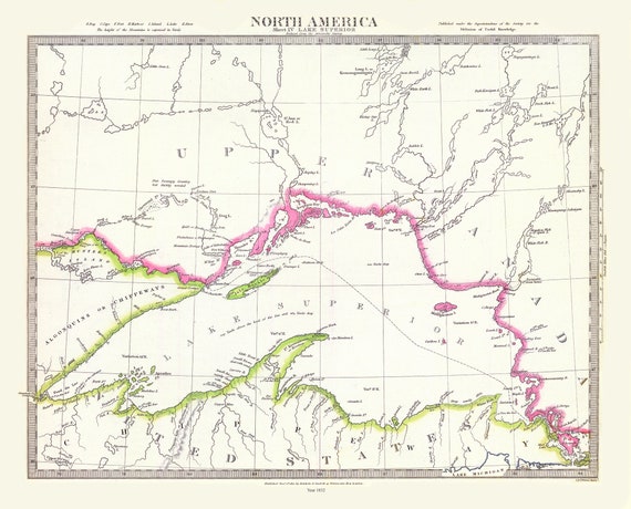
 Lake Superior, Society for the Diffusion of Useful Knowledge auth., 1832, travel poster on heavy cotton canvas, 50 x 70 cm, 20 x 25" approx.
$41.48
Lake Superior, Society for the Diffusion of Useful Knowledge auth., 1832, travel poster on heavy cotton canvas, 50 x 70 cm, 20 x 25" approx.
$41.48
 Northern Michigan and Lake Superior, Rand McNally and Company, 1879 , map on heavy cotton canvas, 50 x 70 cm, 20 x 25" approx.
$41.48
Northern Michigan and Lake Superior, Rand McNally and Company, 1879 , map on heavy cotton canvas, 50 x 70 cm, 20 x 25" approx.
$41.48
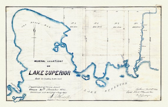 Mineral Locations on Lake Superior, 1864 , map on heavy cotton canvas, 50 x 70 cm, 20 x 25" approx.
$41.48
Mineral Locations on Lake Superior, 1864 , map on heavy cotton canvas, 50 x 70 cm, 20 x 25" approx.
$41.48
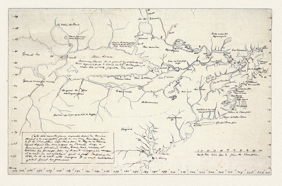
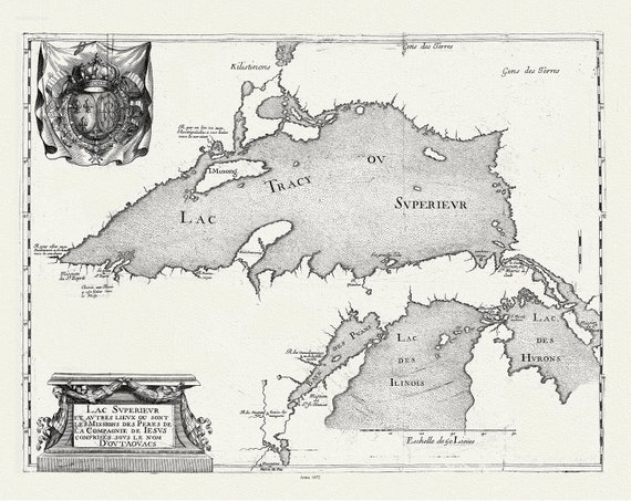 Lac Superieur et autres lieux ou sont les Missions des Peres de la Compagnie de Jesus comprises sous le non D'outaouacs, 1672, 20 x 25"
$41.48
Lac Superieur et autres lieux ou sont les Missions des Peres de la Compagnie de Jesus comprises sous le non D'outaouacs, 1672, 20 x 25"
$41.48
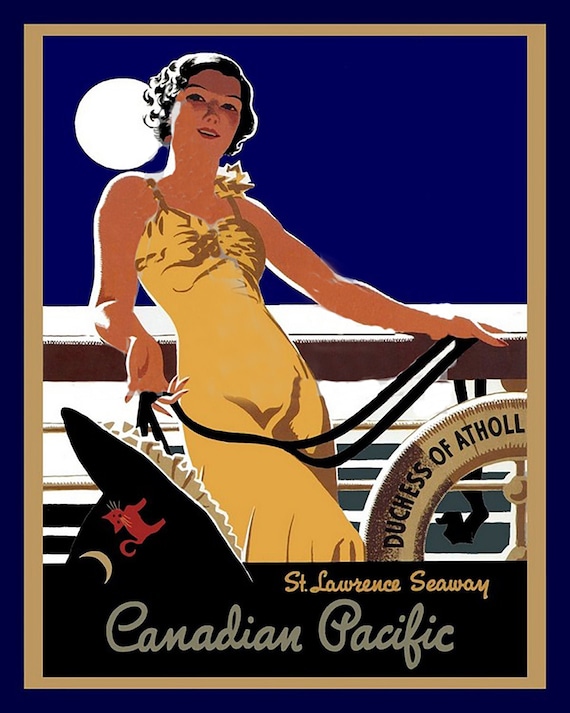 Canadian Pacific, St. Lawrence Seaway, travel poster on heavy cotton canvas, 22x27" approx.
$41.48
Canadian Pacific, St. Lawrence Seaway, travel poster on heavy cotton canvas, 22x27" approx.
$41.48
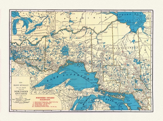 Rand McNally & Company, Commercial Atlas, Northern Ontario, 1924 , map on heavy cotton canvas, 22x27" approx.
$41.48
Rand McNally & Company, Commercial Atlas, Northern Ontario, 1924 , map on heavy cotton canvas, 22x27" approx.
$41.48
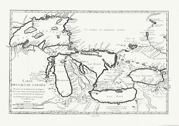 Bellin, Carte des lacs du Canada, Dressée sur les manuscrits du depost des cartes,1744, map on heavy cotton canvas, 50x70cm approx.
$41.48
Bellin, Carte des lacs du Canada, Dressée sur les manuscrits du depost des cartes,1744, map on heavy cotton canvas, 50x70cm approx.
$41.48
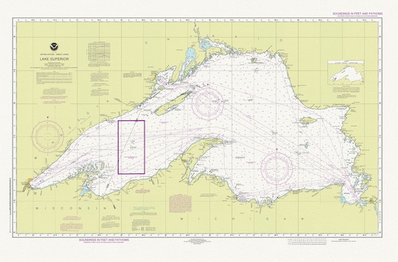 Nautical Chart of Lake Superior, 2016, map on heavy cotton canvas, 50 x 70 cm or 20x25" approx.
$41.48
Nautical Chart of Lake Superior, 2016, map on heavy cotton canvas, 50 x 70 cm or 20x25" approx.
$41.48
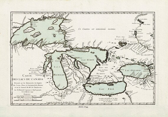 Bellin, Carte des lacs du Canada, 1744 Ver. III, map on heavy cotton canvas, 22x27" approx.
$41.48
Bellin, Carte des lacs du Canada, 1744 Ver. III, map on heavy cotton canvas, 22x27" approx.
$41.48
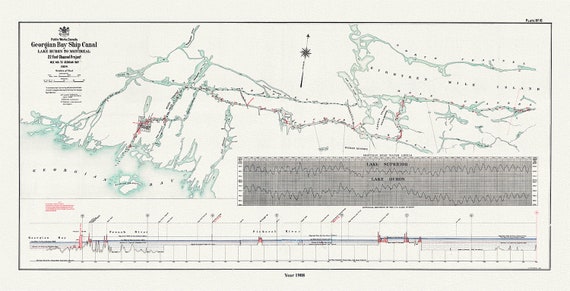 The Georgian Bay Ship Canal from Lake Huron to Montreal, 1908
$41.48
The Georgian Bay Ship Canal from Lake Huron to Montreal, 1908
$41.48
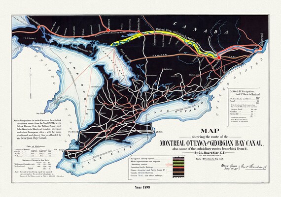 Map shewing the route of the Montreal, Ottawa and Georgian Bay Canal, also subsidiary routes, 1898, on canvas, 50 x 70 cm, 20 x 25" approx.
$41.48
Map shewing the route of the Montreal, Ottawa and Georgian Bay Canal, also subsidiary routes, 1898, on canvas, 50 x 70 cm, 20 x 25" approx.
$41.48
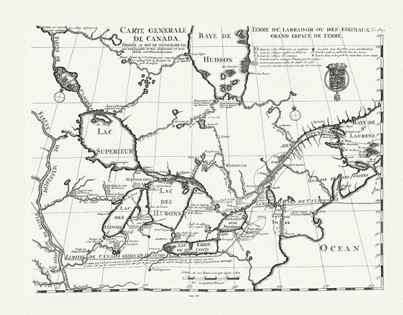 Carte generale de Canada, Lahotan auth., 1706, map on heavy cotton canvas, 50 x 70 cm, 20 x 25" approx.
$41.48
Carte generale de Canada, Lahotan auth., 1706, map on heavy cotton canvas, 50 x 70 cm, 20 x 25" approx.
$41.48
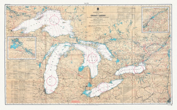 Canada Hydrographic Office, A General Chart of the Great Lakes, 1927 , map on heavy cotton canvas, 50x70cm (20 x 25") approx.
$41.48
Canada Hydrographic Office, A General Chart of the Great Lakes, 1927 , map on heavy cotton canvas, 50x70cm (20 x 25") approx.
$41.48
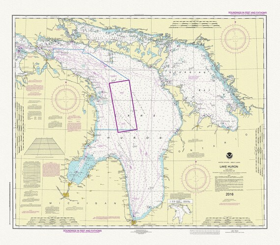 Chart of Lake Huron, 2016, map on heavy cotton canvas, 24 x 27" approx.
$41.48
Chart of Lake Huron, 2016, map on heavy cotton canvas, 24 x 27" approx.
$41.48
 Champlain (1574-1635) et Thoreau-Carte de la Nouvelle France, 1632, map on heavy cotton canvas, 22x27" approx.
$41.48
Champlain (1574-1635) et Thoreau-Carte de la Nouvelle France, 1632, map on heavy cotton canvas, 22x27" approx.
$41.48
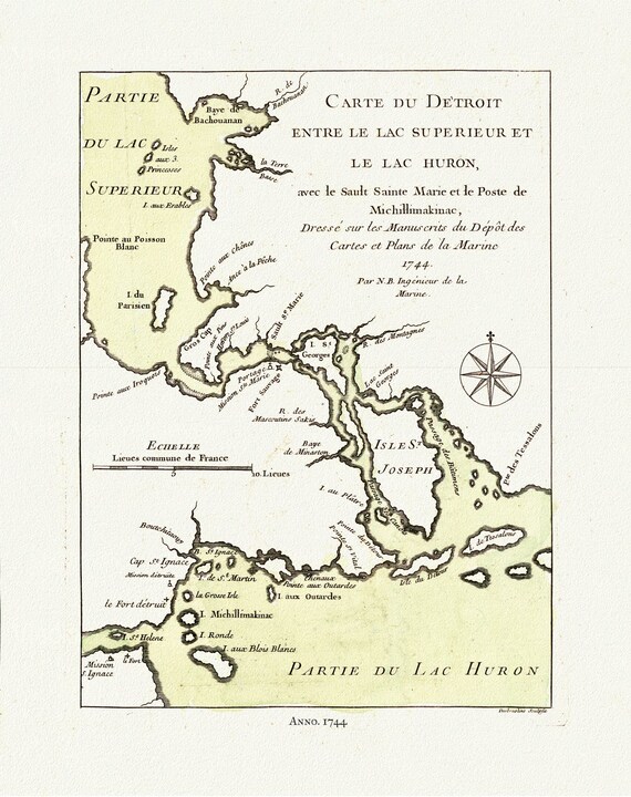 Bellin, Carte du Detroit entre le Lac Superieur et Huron, avec le Sault Ste. Marie, 1744, map on heavy cotton canvas, 50x70cm approx.
$41.48
Bellin, Carte du Detroit entre le Lac Superieur et Huron, avec le Sault Ste. Marie, 1744, map on heavy cotton canvas, 50x70cm approx.
$41.48
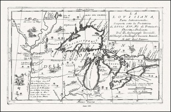 Coronelli, La Louisiana, Parte Settentrionalle, Scoperta sotto Protettione di Luigi XIV, Re di Francia, 1691, cotton canvas, 22x27" approx.
$41.48
Coronelli, La Louisiana, Parte Settentrionalle, Scoperta sotto Protettione di Luigi XIV, Re di Francia, 1691, cotton canvas, 22x27" approx.
$41.48
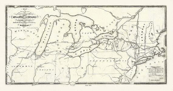 Price, Map showing the direct commercial route from the Atlantic via L. Ontario, to the province of Upper Canada, Mississippi, 1836, 18x27"
$41.48
Price, Map showing the direct commercial route from the Atlantic via L. Ontario, to the province of Upper Canada, Mississippi, 1836, 18x27"
$41.48
 Patten, A trader's map of the Ohio country before 1753, map on heavy cotton canvas, 22x27" approx.
$41.48
Patten, A trader's map of the Ohio country before 1753, map on heavy cotton canvas, 22x27" approx.
$41.48
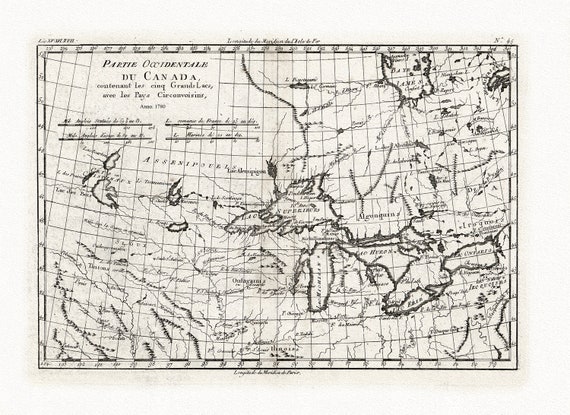 Bonne, Partie Occidentale du Canada, contenant les Cinq Grands Lacs, avec les pays circonvoisins, 1780, map on cotton canvas, 22x27" approx.
$41.48
Bonne, Partie Occidentale du Canada, contenant les Cinq Grands Lacs, avec les pays circonvoisins, 1780, map on cotton canvas, 22x27" approx.
$41.48