
 Bouchette, Map Of The Provinces Of Canada, 1846, map on durable cotton canvas, 50 x 70 cm, 20 x 25" approx.
$34.47
Bouchette, Map Of The Provinces Of Canada, 1846, map on durable cotton canvas, 50 x 70 cm, 20 x 25" approx.
$34.47
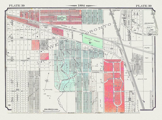 Plate 39, Toronto West, The Junction, 1884 , map on heavy cotton canvas, 20 x 30" approx.
$34.47
Plate 39, Toronto West, The Junction, 1884 , map on heavy cotton canvas, 20 x 30" approx.
$34.47
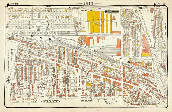 Plate 64, Toronto West, The Junction and Stockyards, 1913, map on heavy cotton canvas, 20 x 30" or 50 x 75cm. approx.
$34.47
Plate 64, Toronto West, The Junction and Stockyards, 1913, map on heavy cotton canvas, 20 x 30" or 50 x 75cm. approx.
$34.47
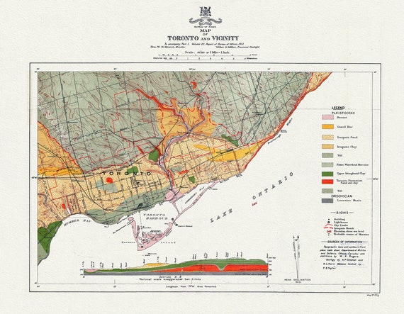 Map of Toronto and Vicinity To accompany part 1, Volume 22, Report of Bureau of Mines, 1913, map on heavy cotton canvas, 22x27" approx.
$34.47
Map of Toronto and Vicinity To accompany part 1, Volume 22, Report of Bureau of Mines, 1913, map on heavy cotton canvas, 22x27" approx.
$34.47
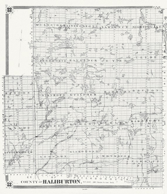 Historic Algonquin Park Map, Haliburton County, 1879, map on heavy cotton canvas, 20 x 25" approx.
$38.30
Historic Algonquin Park Map, Haliburton County, 1879, map on heavy cotton canvas, 20 x 25" approx.
$38.30
 World War I, Map specially indicating scenes where Canadian troops distinguished themselves, 1914, canvas, 20 x 30" or 50 x 75cm. approx.
$34.47
World War I, Map specially indicating scenes where Canadian troops distinguished themselves, 1914, canvas, 20 x 30" or 50 x 75cm. approx.
$34.47
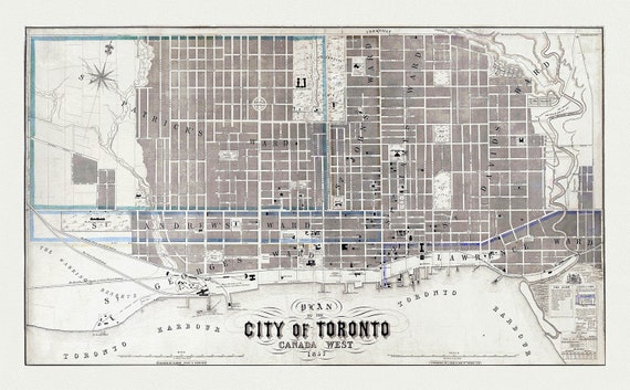 Fleming, Plan of the City of Toronto, Canada West, 1857, map on heavy cotton canvas, 22x27" approx.
$34.47
Fleming, Plan of the City of Toronto, Canada West, 1857, map on heavy cotton canvas, 22x27" approx.
$34.47
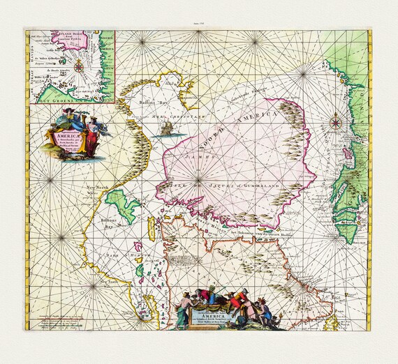 Septemtrionaliora Americæ a Groenlandia, per Freta Davidis et Hudson, ad Terram Novam, 1745, Ottens
$34.47
Septemtrionaliora Americæ a Groenlandia, per Freta Davidis et Hudson, ad Terram Novam, 1745, Ottens
$34.47
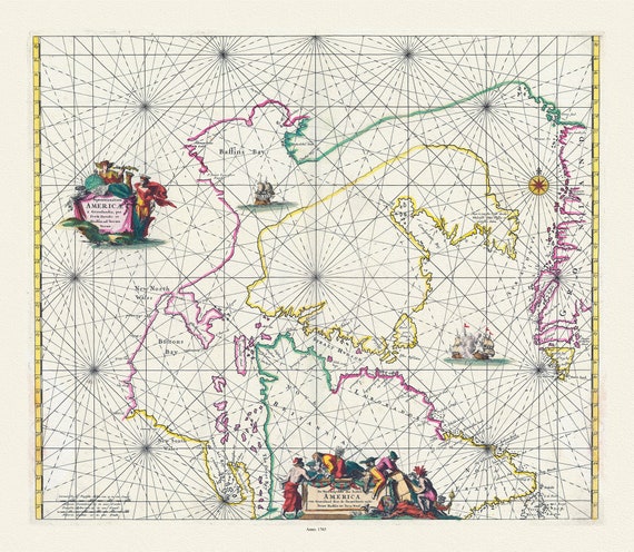
 America Nort, 1667, Goos auth., map on heavy cotton canvas, 50 x 70cm, 20 x 25" approx.
$34.47
America Nort, 1667, Goos auth., map on heavy cotton canvas, 50 x 70cm, 20 x 25" approx.
$34.47
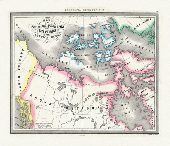 Mari Archipelaghi polari artici dalla Baia d'Hudson all' America Russa, 1858, Marmocchi auth. map on cotton canvas, 20 x 25" approx
$34.47
Mari Archipelaghi polari artici dalla Baia d'Hudson all' America Russa, 1858, Marmocchi auth. map on cotton canvas, 20 x 25" approx
$34.47
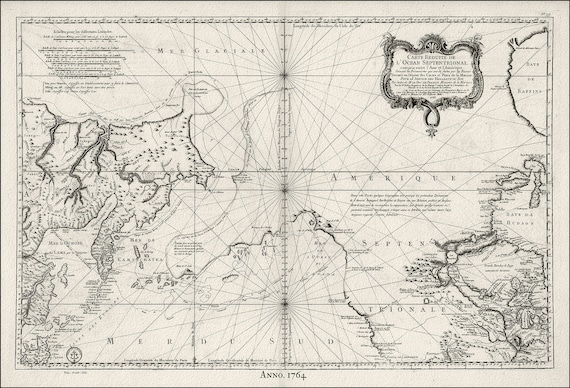
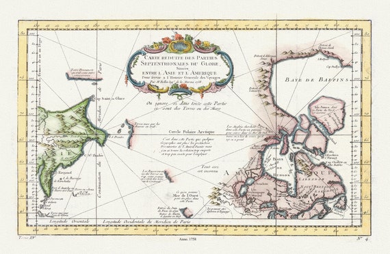 Carte reduite des parties septentrionales du globe, generale des voyages, 1758, Bellin auth., map on heavy cotton canvas,20 x 25" approx.
$34.47
Carte reduite des parties septentrionales du globe, generale des voyages, 1758, Bellin auth., map on heavy cotton canvas,20 x 25" approx.
$34.47
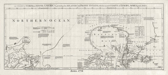 Baffin Bay, Canada, 1776 Jefferys auth., map on heavy cotton canvas, 50 x 70cm, 20 x 25" approx.
$34.47
Baffin Bay, Canada, 1776 Jefferys auth., map on heavy cotton canvas, 50 x 70cm, 20 x 25" approx.
$34.47
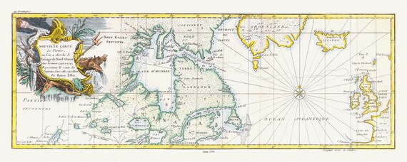 Nouvelle carte des parties, ou lon a cherche le passage de nord-ouest dans les annees 1746 et 1747, Ellis auth. map on canvas, 20 x 25"
$34.47
Nouvelle carte des parties, ou lon a cherche le passage de nord-ouest dans les annees 1746 et 1747, Ellis auth. map on canvas, 20 x 25"
$34.47
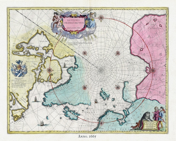 Arctic, 1665, Blaeu auth , map on heavy cotton canvas, 50 x 70cm, 20 x 25" approx.
$34.47
Arctic, 1665, Blaeu auth , map on heavy cotton canvas, 50 x 70cm, 20 x 25" approx.
$34.47
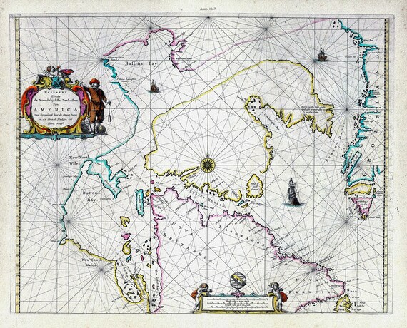
 Witt, Septemtrionaliora Americae a Groenlandia, per Freta Davidis et Hudson, etc., 1765, map on heavy cotton canvas, 20 x 25" approx.
$34.47
Witt, Septemtrionaliora Americae a Groenlandia, per Freta Davidis et Hudson, etc., 1765, map on heavy cotton canvas, 20 x 25" approx.
$34.47
 Pacific NorthWest, Canada 1764 Ver.II, Bellin auth., map on heavy cotton canvas, 50 x 70cm, 20 x 25" approx.
$34.47
Pacific NorthWest, Canada 1764 Ver.II, Bellin auth., map on heavy cotton canvas, 50 x 70cm, 20 x 25" approx.
$34.47
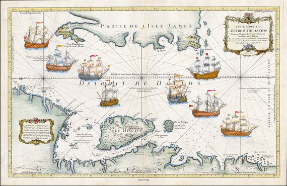
 Davis Strait, 1755, Bellin auth., map on heavy cotton canvas, 50 x 70cm, 20 x 25" approx.
$34.47
Davis Strait, 1755, Bellin auth., map on heavy cotton canvas, 50 x 70cm, 20 x 25" approx.
$34.47
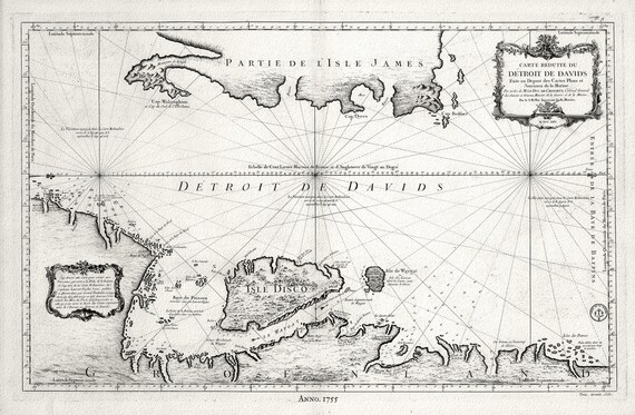
 Detroit de Davids (Davis Strait), 1764. Bellin auth.
$34.47
Detroit de Davids (Davis Strait), 1764. Bellin auth.
$34.47
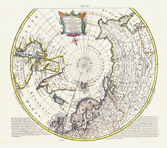 North Pole, with the countries hitherto discovered situated near or adjacent to it as well as some others more remote.1747, canvas 20x25"
$34.47
North Pole, with the countries hitherto discovered situated near or adjacent to it as well as some others more remote.1747, canvas 20x25"
$34.47
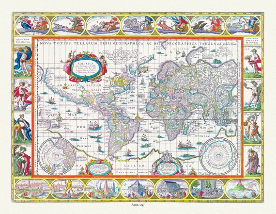 Nova totius terrarum orbis geographica ac hydrographica tabula, 1643, Blaeu authore,bright or dull versions, map, 20x25" approx.
$34.47
Nova totius terrarum orbis geographica ac hydrographica tabula, 1643, Blaeu authore,bright or dull versions, map, 20x25" approx.
$34.47